BEARING 287°
THE TRAIL APP
FOR YOUR RIG.
Mounted in the dash. Built for the ride. Voice turn-by-turn on real trails, ride recording, music. iPad and iPhone, paired live over local Wi-Fi. All offline. Built by riders.
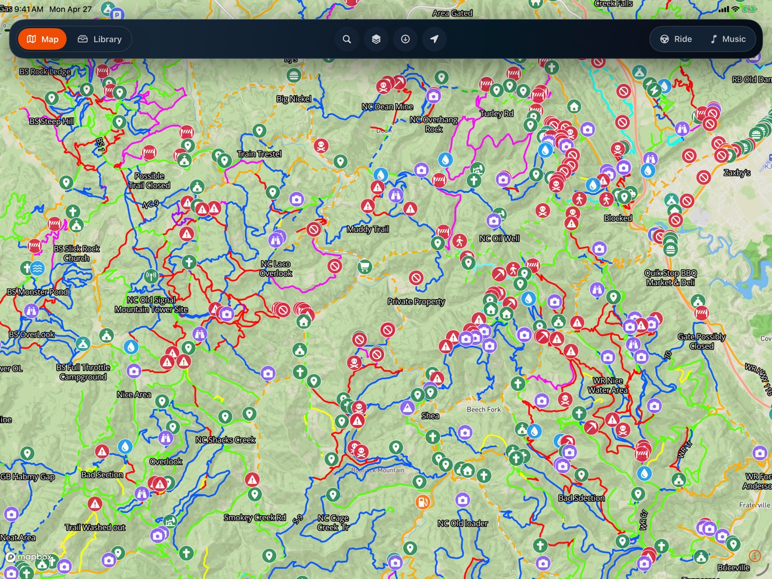
RIDE THE
REAL TRAILS.
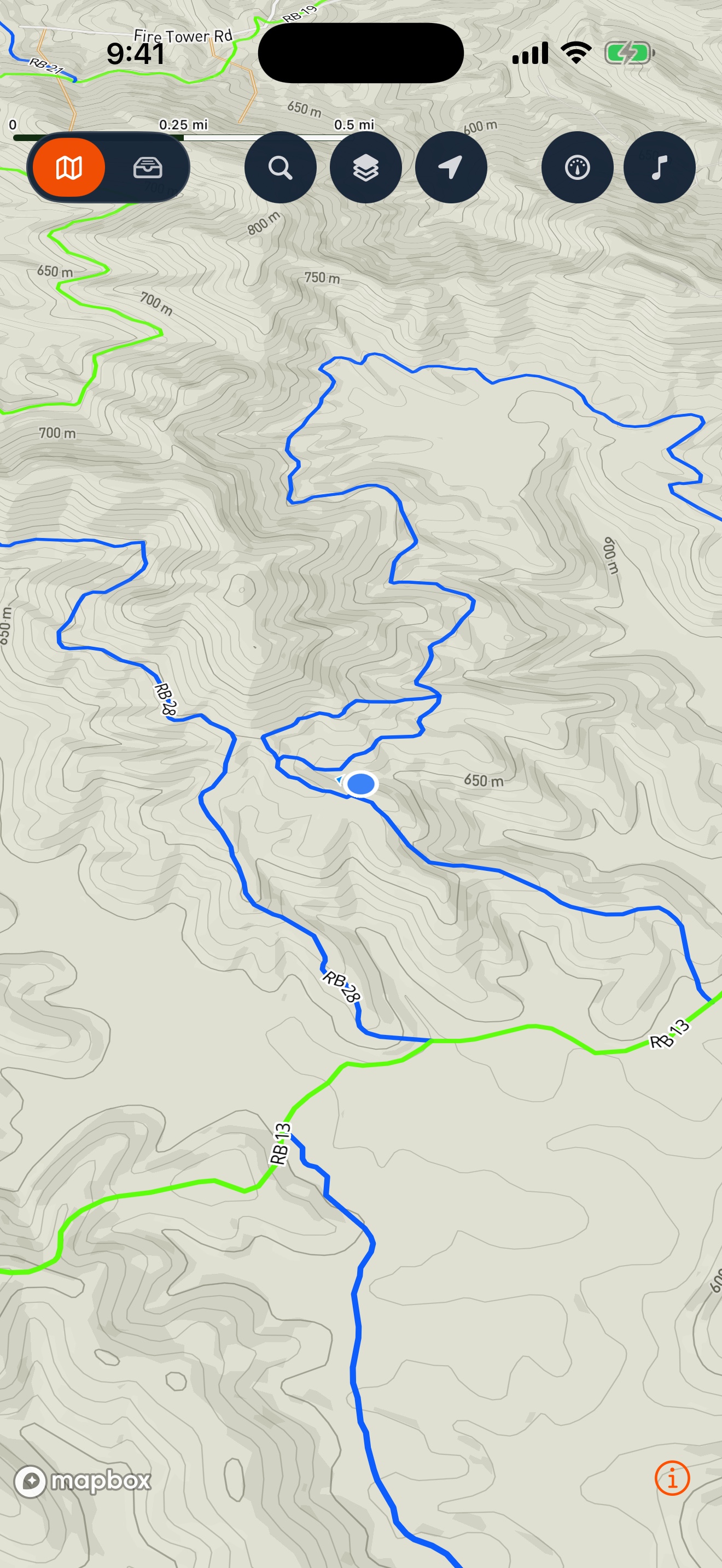
Live preview from the West Virginia public-lands pack. Pan to scope the terrain. Zoom to pick your line. Every single trail ships on your device, offline and ready.
Trails © Gather Offroad pack wv-va-ky-public · Spearhead + Hatfield-McCoy region · public lands
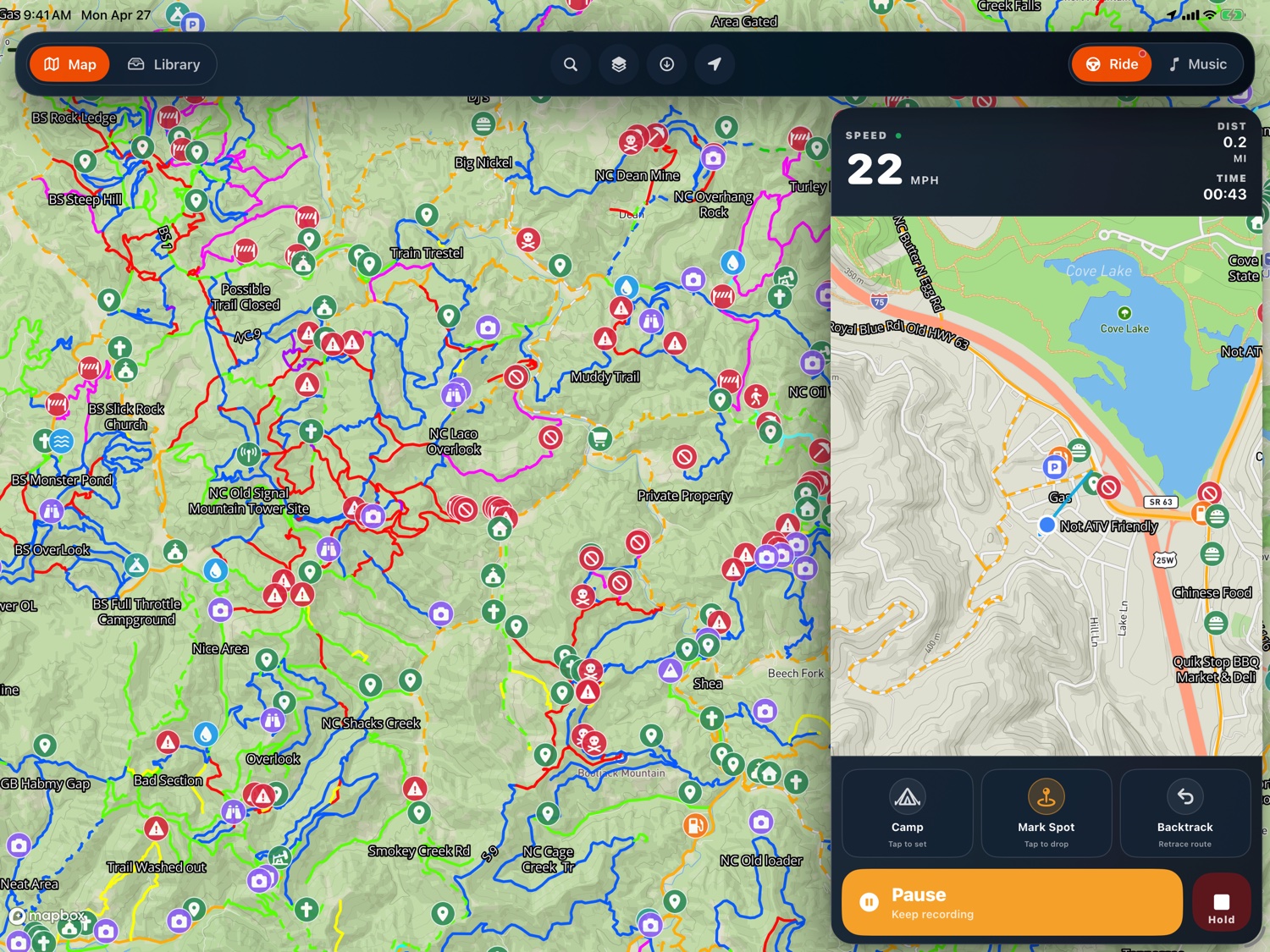
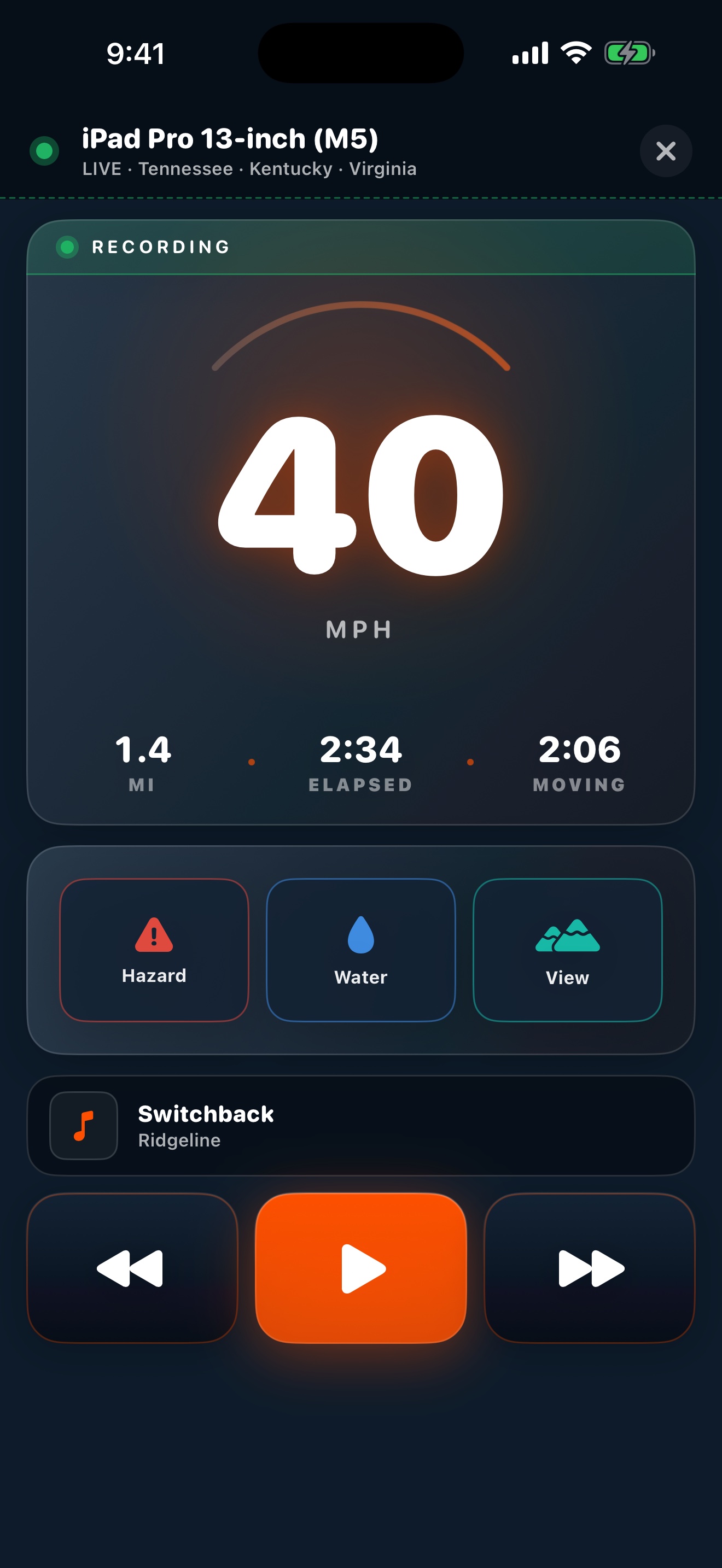
TRACK EVERY
MILE. WITH
ZERO BARS.
Pause, mark, backtrack with one tap. Stop takes a 1-second hold so a dash bump never ends your ride for you.
-
01.1
EVERY FOOT RECORDED
Breadcrumb tracks every position the GPS sees. Closed canopy, canyons, and tunnels gap, then resume the moment your signal returns.
-
01.2
LIVE READOUT
Speed. Distance. Elapsed time. Climb. All live on the dash, all the time.
-
01.3
ONE-TAP CONTROLS
Start, pause, stop. Sized to be hit reliably with a gloved thumb without looking down.
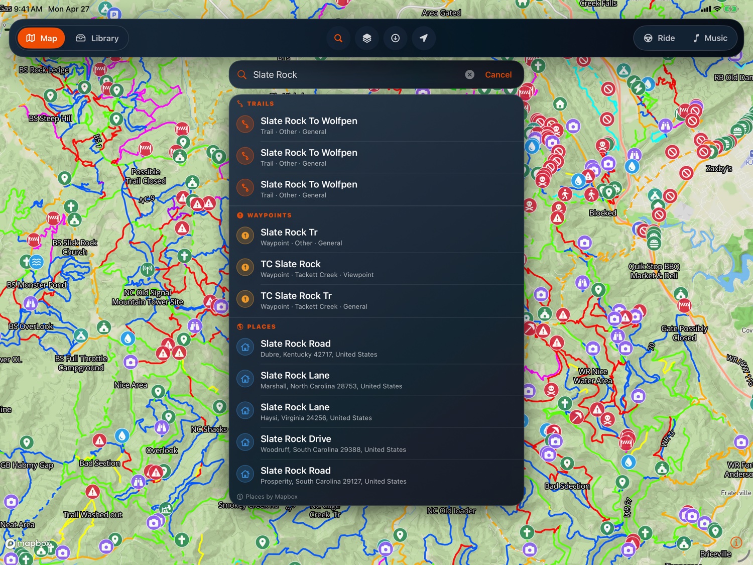
TYPE TWO
LETTERS.
FIND THE TRAIL.
Type a name. Trails, roads, towns. Your pack content lands right next to address results so you can jump from a trailhead to a gas station in the same search. One tap drops you there.
-
02.1
TYPE A NAME
Trails, roads, towns. A few letters and they show up.
-
02.2
RANKED BY MAP
Results match what you're already looking at, not the other side of the country.
-
02.3
TAP TO FLY
One tap and the camera lands on your pick.
-
02.4
GO FROM HERE
Drop a pin at the result and route to it without leaving the screen.
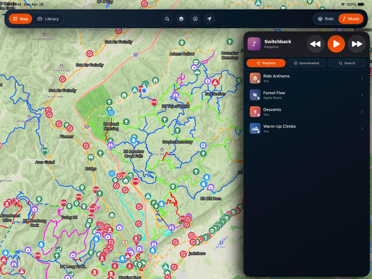
MAP STAYS.
MUSIC
SLIDES IN.
Built-in Apple Music panel for the playlists you already downloaded. Works offline.
-
03.1
YOUR DOWNLOADED MIX
Apple Music playlists you already have on the device.
-
03.2
BIG BUTTONS FOR COLD HANDS
Play, pause, skip. Sized for hands you can't really feel.
-
03.3
STAYS WITH THE MAP
The map never leaves the screen. Music slides in from the side.
-
03.4
LIVE ON LOCK SCREEN
Track info shows on the Lock Screen and iPhone Dynamic Island.
ONE RIDE.
PAIRED LIVE.
The iPhone runs the full app. Same packs, same offline trails, same ride recording. Or pair it with an iPad over local Wi-Fi to mirror ride state, drop pins from your handlebar GPS, and control music without reaching across the cab. No cloud, no account sync, no internet.
-
04.1
LIVE TELEMETRY MIRROR
Speed, distance, and time stream from the iPad to your iPhone so you can glance without taking a hand off the bars.
-
04.2
MARK SPOT FROM YOUR HAND
Drop a pin from the iPhone where you stand. Tap Hazard, Water, or View. The iPad logs it on the active ride. No reaching across the cab.
-
04.3
MUSIC AT YOUR THUMB
Skip a track from the bars. Big buttons sized for cold hands. Music comes from the iPad's library; the iPhone just runs the dial.
-
04.4
LOCAL NETWORK ONLY
Pair once via QR code. Reconnects automatically every time you're on the same Wi-Fi. Ride state, music state, marker drops: it all stays in your cab. No cloud, no account sync, no internet needed.
UNDER THE
HOOD.
OFFLINE TRAIL PACKS
One file per region. Thousands of trails, every waypoint, and full turn-by-turn, all sitting on your device. Each download is checked end to end. Anything tampered with gets rejected.
VOICE TURN-BY-TURN
Pick where you're headed. Choose all-trails, mixed, or mostly road. Spoken turns at every junction. Wander off and it quietly recalculates.
CAMP GUIDE & MARKS
Drop a camp pin and the app draws you a line back from wherever you are. Mark hazards, water, or a view with one tap. Tap by mistake? An undo button catches it.
REAL PACKS ONLY
Every pack list is signed by us before it leaves the server. The app checks the signature before it touches anything. If it doesn't match, it doesn't load. Nobody can slip you a fake pack.
LIVE ACTIVITY
Lock the screen mid-ride and the Dynamic Island and Lock Screen keep showing speed, distance, and ride time. Tap to come back into the dashboard.
YOUR RIDES STAY YOURS
Routes you record live on the device. The app never uploads them. Share with friends when you want, by exporting yourself.
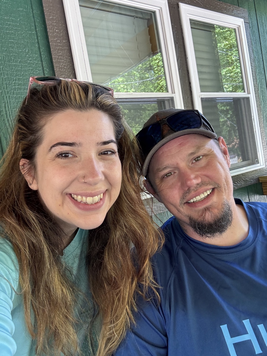
TWO RIDERS.
FIVE KIDS.
TWO DOGS.
ONE MISSION.
We're Andrew and Brandy. A husband and wife in Virginia with full-time jobs, riding every weekend we can. We grew up riding. Then life happened. Careers, kids, the whole thing, and for years the trails were just a memory.
Then friends took us out to West Virginia and handed us the keys to a Honda Pioneer. A few weekends later, Busco Beach in North Carolina. That was it. We came home knowing exactly what we were doing next.
Now it's a Can-Am X3 MAX XRS RR with the whole crew. Five kids. Two dogs. It gets loud. It's absolutely worth it.
We built Gather Offroad because every trail app we tried gave up the moment our phones did. They wanted accounts. They wanted subscriptions. They needed cell service just to show the map. Out where we ride, none of that exists. To us, that's not a bug. It's the whole reason we're there.
"Gather Offroad isn't here to cash in on the community. It's built to keep the community connected."
TWO PACKS
LIVE.
MORE ON THE WAY.
Each pack is one file with everything you need offline. Real trails sorted from paved roads, waypoints with the right icons, voice turn-by-turn, and a color legend that matches the area you're riding.
Riding somewhere not yet covered? Drop us a note. We're always working on the next region.
Tennessee · Kentucky · Virginia
Windrock · Brimstone · Royal Blue · Tackett Creek · Catoosa · Pickett · Hillbilly + Adventure parks
AI-classified icons, hazard pins re-tinted, color legend baked in. Full routable trail graph.
West Virginia · Virginia · Kentucky
Spearhead + Hatfield-McCoy region · public lands across WV / VA / KY
Routable trail graph + voice turn-by-turn navigation ready.
WE DON'T WANT
YOUR DATA.
The app installs empty. Trail packs are public files, served without cookies. Use it for years without ever making an account. Sign in with Apple if you want your installed packs to follow you to a new device. That's the only thing we use it for.
NO ADVERTISING
We don't serve ads. We don't carry trackers. We don't sell data. There's nothing to sell.
NOTHING REPORTS BACK
No third parties watching the app over your shoulder. The one thing we record is whether your pack download finished, and only if you're signed in.
ACCOUNT IS OPTIONAL
If you do sign in, we use it for one thing: bringing your installed packs over when you switch devices. We never email you. We never share it.
MAPBOX IS MUTED
Mapbox runs the underlying basemap. We turn off everything it would otherwise log about where you go and how you use the app.
READY
WHEN YOU ARE.
Free on the App Store. iPad and iPhone, one universal install. No accounts required to ride. Pack updates land for free as we publish them.
Want a heads-up when new trail packs drop or a new release lands? Drop your email. One short note when something actually ships.
▲ NO SPAM · NO MARKETING LIST · NO FOLLOW-UPS